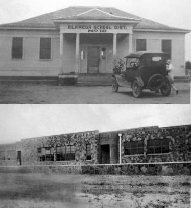
 ALAMEDA
The community of Alameda reached its peak in the late 19th century.
Only the cemetery remains today with the first grave dated 1860. The
settlement began in 1859 and was originally called Mansker's Lake,
after the Mansker family, who first settled in the area and donated
some of the land for the cemetery. There's still a little lake nearby
today, which is called Mansker Lake. School was organized in 1883 and
consolidated with Ranger in 1944. Aubrey Warford taught school there.
 ALLEN
Located 9 miles east of Ranger. A school was organized in 1883 and
consolidated with Tudor in 1896.
BRUSHY POINT
CASE KNIFE was located near Ranger. A school was organized in 1885.
 CHEANEY
Located near Alameda. This is the second Cheaney School in
1915 after the original two-story building burned. The school
building was moved to Alameda later. If you have information
on this area, contact Jeff Clark at jeffclarktexas@gmail.com.
COLONY must have been a community for there was a school and
cemetery. It was located 5 miles from Ranger.
COOK CANYON was located near Alameda.
 CROSS ROADS
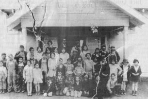
Located about 3 1/2 milses southeast of Ranger. A school was
organized in 1891 and consolidated with Ranger in 1949.
Cross Roads Singing School in 1910
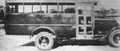 Cross Roads school bus
FIR - a mile south of the original Mansker Lake community.
 FLATWOOD
A school was organized in 1887 and continued until 1944 when it was
consolidated with Carbon. The area is still a farming community.
FRANKELL
This article is taken from an interview with Ben Yung, Jr., 80, of
Fort Worth, who lived in Frankell from 1926-37 and attended school
there until his family moved to Ranger. Another source of information
was the printed history of Stephens County.
The school, with its eleven grades in a brick building, probably
ceased to function during the time of Word War II. Mr. Young recalls
that one of the teachers was Ovesta McClesky.
Mr. Yung remembers two large general stores (one was owned by the
Van Gardenhires), the post office (founded in 1923; the first
postmaster was Lige Langford), and a large train depot. The county
history lists two grocery stores, a bank, two service stations, a
drug store, and a barbershop operated by my great uncle King
Herrington. There was also a two-story hotel that was used mostly
by railroad passengers. The town was approximately 18 miles south
of Breckenridge and reached a maximum population of 250. The town
covered an area of some two square miles and was at its peak from
1910-1924. The railroad was used primarily to ship cattle and to
provide passenger service.
The town built by Jake Hamon and Frank Kell, who put in a railroad
that ran from Wichita Falls to Dublin. Commonly referred to as the
Jake Hamon, the railroad’s proper name was Wichita Falls and Southern
Railroad. The fact that Necessity refused to cooperate with the two
men and was bypassed by the railroad resulted in the death of the
community of Necessity. There was a community closer to Dublin named
for Jake Hamon so that both railroad entrepreneurs had towns named
for them. Some time in the 1950’s the ties of the railroad were taken
up and sold. Mike Herrington recalls that his father bought a quarter
mile of them to use as fence posts in building a bull pen on their
dairy farm.
When the town ceased to exist, the site was bought and turned into
farmland by the family still living there.
GUNSIGHT
Located in Stephens County with only six residents as of the last
census. The town dates back to 1879 and got the name after the low
mountains which form a V-shoped of a gunsight. It once had a post
office but never grew much from the railroad or oil bloom.
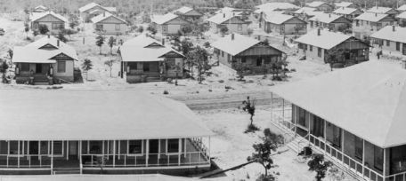 HUMBLETOWN developed near Cisco by the Humble Oil Co.
for their employees in 1919 during the oil boom.
HUNTER
Located about 6 miles SE of Ranger. A school was organized in 1904
and consolidated with Cross Roads in 1920.
LACASA
The Oakley community located in Stephens County near Ranger had 75
people on the 1920 census. A post office opened in 1890 in the general
store.
LEERAY
A bank vault in the middle of a pasture is the only thing that remains
of the town of Leeray. The town was located past Eastland Hill off
the Breckenridge Highway which may actually be Stephen county. During
its boom time, there were over 6000 people. When the oil played out,
the town was torn down and moved to West Texas. Nitro was manufactured
here and at one time there was a huge explosion which was heard as far
as Ranger.
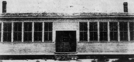
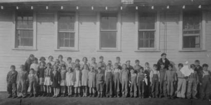 Lone Cedar School in 1928
LONG CEDAR
Located east of Ranger. The school was later consolidated with Alameda.
LONG BRANCH
Located 6 miles southwest of Carbon. For a short time it was home of a
gas plant of the Lone Star Gas Company. By 1989 after the plant closed
only a church and cemetery remained.
MANGUM
Located 7 miles SE of Eastland on CR 192. Residents established a school
in 1900 known as High Point. Hot springs in Mangum gained a reputation
as curative, and the water was bottled and shipped throughout Texas. The
coummunity of 500 started to decline in the 1920s with the removal of
rail lines. The Mangum Baptist Church is still active today.
MARSTON
Located about six miles east of Ranger. A school organized in 1910 and
transferred to Tudor in 1921.
MERRIMAN
Located on Farm Road 2461 four miles south of Ranger was the original
county seat in 1874. An election in 1875 made Eastland the county seat,
and Merriman lost its prospects for growth. Even the oil boom in the
region from 1917 to 1925 did not revive the community. In 1983 there
were a church, cemetery, and a business. The population was estimated
at fourteen in 1990. The school was organized in 1883 and consolidated
with Ranger in 1922.
MOUNTAIN VIEW
Located about eight miles southwest of Ranger. School organized in 1884
and transferred to Cross Roads in 1901.
NECESSITY
OWEN
Located about six miles south of Ranger. A school was organized in 1885
and consolidated with Alameda in 1930.
 Pleasant Grove Picnic in 1903
PLEASANT GROVE COMMUNITY
This community, now extinct except for the cemetery, was a thriving
community with a school and two churches. The community was located
east of Morton Valley, about a mile south of Hwy. 101 on the Country
Road that is east of Hwy.1852. The social life centered around the
community, church, and school with parties, picnics, boating, and box
suppers.
RUSSELL CREEK
Located southeast of Ranger. A school was organized in 1883 and added
to Bullock in 1924.
RUSTLER
Abandoned by 1945 this community was a supply point for ranchers. Rustler
had a post office operating from 1905 to 1908.
SALEM
Located south of Ranger near Alameda. A school was organized in 1895
and moved to Alameda in 1935.
SIPE SPRINGS
Thousand swarmed into this small village during the boom but moved
after it faded. Located east of Rising Star.
 Tanner School in 1921
TANNER
Located 12 miles southeast of Ranger. A school was organized in 1904
and dissolved in 1928. Now know as the Tanner neighborhood.
THURBER
The Lone Star region offers a large variety of natural resources. They
include crude oil, natural gas, sulfur, sand, gravel and wind power, to
name just a few, and each has an interesting story to tell. In this
issue of Landscapes (Publication of Lone Star Land Bank), however, we
have chosen to highlight a resource that not too many people think of
any more - coal.
Today in the United States we see many people seeking work from other
countries, but this is nothing new. In 1888 people from Italy, Hungary,
Austria, Wales, Canada, Scotland, Germany, Sweden, Switzerland, Belgium,
United Kingdom, France Poland, Spain and Ireland came to the town of
Thurber, Texas, seeking work. You would have thought the attraction
was a gold mine but it was "coal mines" that brought hard working
people to Texas.
Coal is the most plentiful fossil fuel source in the United States,
and here in Texas it provides over 40 percent of our state's electrical
needs. While other forms of fuel have experienced more than triple-
digit cost increases, coal has had a less than 10 percent increase in
cost in the last 15 to 20 years.
In and around Palo Pinto and Erath counties, coal has always been
associated with Thurber, Texas. For those who are not familiar with
Thurber's story, it should prove interesting.
Thurber was supposedly the first totally unionized town in Texas. Coal
was discovered in the area in the latter half of the 19th century. Coal
mines were initiated in the Thurber area in 1886, and the mines were sold
to Texas & Pacific Coal Co. in 1888. T&P owned the complete operation
thereafter, including all stores, businesses and services. Unless you
worked for T&P, you basically were not welcome in Thurber.
Where there are union there often are disputes about wages. Thurber was
no different in this regard. One of the earliest disputes appeared to
be over the company charging the workers a dollar a month to ride the
company train to work. Texas Rangers were called in more than once to
settle disputes. The miners typically earned $40 to $60 per month.
Employees were sometimes issued coupons before payday, which were re-
deemable only in the company stores. This apparently got many miners
in financial trouble as they sometimes found most if not all, of their
wages already owed to the company store.
Thurber apparently lasted a period of roughly 50 years and reportedly
employed people from 20 counties. During this period, more than 14
million tons of coal was mined from 15 mines. However, as the new
railroads found that oil was a cheaper and more usable source of fuel,
the coal areas began to die out. Thurber was no exception, even though
large reserves of coal remain underground in the area.
During its heyday, Thurber had drugstores, grocery stores, the company
offices, hotels, a library, opera house, ice house, bandstand, dry goods
and furniture stores. It also had probably more than its share of
saloons. But also in evidence were Methodist, Baptist, Christian, and
Catholic churches.
It was also well known in its day for the production of brick. Today,
Thurber brick is on many city streets in the surrounding area. A huge
smokestack, built to generate electric power, is still evident along
I-20 between Ranger and Weatherford.
Thurber currently has a population of 10 and is the site of two restaurants,
one of which is housed in an original building of the time. Also still
evident are the old residences of the T&P general manager and doctor.
Gaves in the cemetery date to the 1880s.
As you drive west from the metroplex and approach the exits for Gordon
and Mingus, watch for the old smokestack and pull in for a few minutes.
You will enjoy the aura of history that surrounds you.
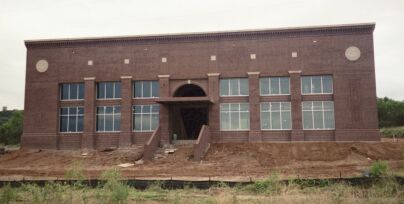 W.K. Gordon Center for Industrial History of Texas Museum
in Thurber opened Nov. 1, 2002. The Center is a research
facility of Tarleton State University. (call 254-968-9890
for information)
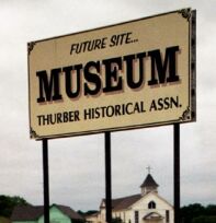
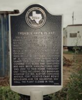 TexasEscapes.com website on Thurber
The Thurber Historical Association website
THURMAN
TIFFIN
Had a population of 1000 in the 1920 census. It was a
switch station on the T&P Railroad and located north-east
of Ranger on Tiffin Road. Their school later joined the
Ranger ISD and was torn down in 1934. After the oil boom,
everyone moved away. The site of the town maybe on private
property now.
TRIUMPH - NA
TUDOR
Located about ten miles east of Ranger. School organized in
1885 and discontinued in 1928.
WAYLAND
Located 17 miles from Ranger in Stephens County. It was a
stagecoach way station in the late 1800s. The post office
opened in 1877 and closed in 1945. The old schoolhouse is
still used for country music sessions. The Wayland Cemetery
is behind the schoolhouse.
YOUNG SPRINGS
ALAMEDA The community of Alameda reached its peak in the late 19th century. Only the cemetery remains today with the first grave dated 1860. The settlement began in 1859 and was originally called Mansker's Lake, after the Mansker family, who first settled in the area and donated some of the land for the cemetery. There's still a little lake nearby today, which is called Mansker Lake. School was organized in 1883 and consolidated with Ranger in 1944. Aubrey Warford taught school there.
ALLEN Located 9 miles east of Ranger. A school was organized in 1883 and consolidated with Tudor in 1896. BRUSHY POINT CASE KNIFE was located near Ranger. A school was organized in 1885.
CHEANEY Located near Alameda. This is the second Cheaney School in 1915 after the original two-story building burned. The school building was moved to Alameda later. If you have information on this area, contact Jeff Clark at jeffclarktexas@gmail.com. COLONY must have been a community for there was a school and cemetery. It was located 5 miles from Ranger. COOK CANYON was located near Alameda.
CROSS ROADS Located about 3 1/2 milses southeast of Ranger. A school was organized in 1891 and consolidated with Ranger in 1949. Cross Roads Singing School in 1910
Cross Roads school bus FIR - a mile south of the original Mansker Lake community.
FLATWOOD A school was organized in 1887 and continued until 1944 when it was consolidated with Carbon. The area is still a farming community. FRANKELL This article is taken from an interview with Ben Yung, Jr., 80, of Fort Worth, who lived in Frankell from 1926-37 and attended school there until his family moved to Ranger. Another source of information was the printed history of Stephens County. The school, with its eleven grades in a brick building, probably ceased to function during the time of Word War II. Mr. Young recalls that one of the teachers was Ovesta McClesky. Mr. Yung remembers two large general stores (one was owned by the Van Gardenhires), the post office (founded in 1923; the first postmaster was Lige Langford), and a large train depot. The county history lists two grocery stores, a bank, two service stations, a drug store, and a barbershop operated by my great uncle King Herrington. There was also a two-story hotel that was used mostly by railroad passengers. The town was approximately 18 miles south of Breckenridge and reached a maximum population of 250. The town covered an area of some two square miles and was at its peak from 1910-1924. The railroad was used primarily to ship cattle and to provide passenger service. The town built by Jake Hamon and Frank Kell, who put in a railroad that ran from Wichita Falls to Dublin. Commonly referred to as the Jake Hamon, the railroad’s proper name was Wichita Falls and Southern Railroad. The fact that Necessity refused to cooperate with the two men and was bypassed by the railroad resulted in the death of the community of Necessity. There was a community closer to Dublin named for Jake Hamon so that both railroad entrepreneurs had towns named for them. Some time in the 1950’s the ties of the railroad were taken up and sold. Mike Herrington recalls that his father bought a quarter mile of them to use as fence posts in building a bull pen on their dairy farm. When the town ceased to exist, the site was bought and turned into farmland by the family still living there. GUNSIGHT Located in Stephens County with only six residents as of the last census. The town dates back to 1879 and got the name after the low mountains which form a V-shoped of a gunsight. It once had a post office but never grew much from the railroad or oil bloom.
HUMBLETOWN developed near Cisco by the Humble Oil Co. for their employees in 1919 during the oil boom. HUNTER Located about 6 miles SE of Ranger. A school was organized in 1904 and consolidated with Cross Roads in 1920. LACASA The Oakley community located in Stephens County near Ranger had 75 people on the 1920 census. A post office opened in 1890 in the general store. LEERAY A bank vault in the middle of a pasture is the only thing that remains of the town of Leeray. The town was located past Eastland Hill off the Breckenridge Highway which may actually be Stephen county. During its boom time, there were over 6000 people. When the oil played out, the town was torn down and moved to West Texas. Nitro was manufactured here and at one time there was a huge explosion which was heard as far as Ranger.
Lone Cedar School in 1928 LONG CEDAR Located east of Ranger. The school was later consolidated with Alameda. LONG BRANCH Located 6 miles southwest of Carbon. For a short time it was home of a gas plant of the Lone Star Gas Company. By 1989 after the plant closed only a church and cemetery remained. MANGUM Located 7 miles SE of Eastland on CR 192. Residents established a school in 1900 known as High Point. Hot springs in Mangum gained a reputation as curative, and the water was bottled and shipped throughout Texas. The coummunity of 500 started to decline in the 1920s with the removal of rail lines. The Mangum Baptist Church is still active today. MARSTON Located about six miles east of Ranger. A school organized in 1910 and transferred to Tudor in 1921. MERRIMAN Located on Farm Road 2461 four miles south of Ranger was the original county seat in 1874. An election in 1875 made Eastland the county seat, and Merriman lost its prospects for growth. Even the oil boom in the region from 1917 to 1925 did not revive the community. In 1983 there were a church, cemetery, and a business. The population was estimated at fourteen in 1990. The school was organized in 1883 and consolidated with Ranger in 1922. MOUNTAIN VIEW Located about eight miles southwest of Ranger. School organized in 1884 and transferred to Cross Roads in 1901. NECESSITY OWEN Located about six miles south of Ranger. A school was organized in 1885 and consolidated with Alameda in 1930.
Pleasant Grove Picnic in 1903 PLEASANT GROVE COMMUNITY This community, now extinct except for the cemetery, was a thriving community with a school and two churches. The community was located east of Morton Valley, about a mile south of Hwy. 101 on the Country Road that is east of Hwy.1852. The social life centered around the community, church, and school with parties, picnics, boating, and box suppers. RUSSELL CREEK Located southeast of Ranger. A school was organized in 1883 and added to Bullock in 1924. RUSTLER Abandoned by 1945 this community was a supply point for ranchers. Rustler had a post office operating from 1905 to 1908. SALEM Located south of Ranger near Alameda. A school was organized in 1895 and moved to Alameda in 1935. SIPE SPRINGS Thousand swarmed into this small village during the boom but moved after it faded. Located east of Rising Star.
Tanner School in 1921 TANNER Located 12 miles southeast of Ranger. A school was organized in 1904 and dissolved in 1928. Now know as the Tanner neighborhood. THURBER

 The Lone Star region offers a large variety of natural resources. They include crude oil, natural gas, sulfur, sand, gravel and wind power, to name just a few, and each has an interesting story to tell. In this issue of Landscapes (Publication of Lone Star Land Bank), however, we have chosen to highlight a resource that not too many people think of any more - coal. Today in the United States we see many people seeking work from other countries, but this is nothing new. In 1888 people from Italy, Hungary, Austria, Wales, Canada, Scotland, Germany, Sweden, Switzerland, Belgium, United Kingdom, France Poland, Spain and Ireland came to the town of Thurber, Texas, seeking work. You would have thought the attraction was a gold mine but it was "coal mines" that brought hard working people to Texas. Coal is the most plentiful fossil fuel source in the United States, and here in Texas it provides over 40 percent of our state's electrical needs. While other forms of fuel have experienced more than triple- digit cost increases, coal has had a less than 10 percent increase in cost in the last 15 to 20 years. In and around Palo Pinto and Erath counties, coal has always been associated with Thurber, Texas. For those who are not familiar with Thurber's story, it should prove interesting. Thurber was supposedly the first totally unionized town in Texas. Coal was discovered in the area in the latter half of the 19th century. Coal mines were initiated in the Thurber area in 1886, and the mines were sold to Texas & Pacific Coal Co. in 1888. T&P owned the complete operation thereafter, including all stores, businesses and services. Unless you worked for T&P, you basically were not welcome in Thurber. Where there are union there often are disputes about wages. Thurber was no different in this regard. One of the earliest disputes appeared to be over the company charging the workers a dollar a month to ride the company train to work. Texas Rangers were called in more than once to settle disputes. The miners typically earned $40 to $60 per month. Employees were sometimes issued coupons before payday, which were re- deemable only in the company stores. This apparently got many miners in financial trouble as they sometimes found most if not all, of their wages already owed to the company store. Thurber apparently lasted a period of roughly 50 years and reportedly employed people from 20 counties. During this period, more than 14 million tons of coal was mined from 15 mines. However, as the new railroads found that oil was a cheaper and more usable source of fuel, the coal areas began to die out. Thurber was no exception, even though large reserves of coal remain underground in the area. During its heyday, Thurber had drugstores, grocery stores, the company offices, hotels, a library, opera house, ice house, bandstand, dry goods and furniture stores. It also had probably more than its share of saloons. But also in evidence were Methodist, Baptist, Christian, and Catholic churches. It was also well known in its day for the production of brick. Today, Thurber brick is on many city streets in the surrounding area. A huge smokestack, built to generate electric power, is still evident along I-20 between Ranger and Weatherford. Thurber currently has a population of 10 and is the site of two restaurants, one of which is housed in an original building of the time. Also still evident are the old residences of the T&P general manager and doctor. Gaves in the cemetery date to the 1880s. As you drive west from the metroplex and approach the exits for Gordon and Mingus, watch for the old smokestack and pull in for a few minutes. You will enjoy the aura of history that surrounds you.
W.K. Gordon Center for Industrial History of Texas Museum in Thurber opened Nov. 1, 2002. The Center is a research facility of Tarleton State University. (call 254-968-9890 for information)

TexasEscapes.com website on Thurber The Thurber Historical Association website THURMAN TIFFIN Had a population of 1000 in the 1920 census. It was a switch station on the T&P Railroad and located north-east of Ranger on Tiffin Road. Their school later joined the Ranger ISD and was torn down in 1934. After the oil boom, everyone moved away. The site of the town maybe on private property now. TRIUMPH - NA TUDOR Located about ten miles east of Ranger. School organized in 1885 and discontinued in 1928. WAYLAND Located 17 miles from Ranger in Stephens County. It was a stagecoach way station in the late 1800s. The post office opened in 1877 and closed in 1945. The old schoolhouse is still used for country music sessions. The Wayland Cemetery is behind the schoolhouse. YOUNG SPRINGS